Surfboard: Geospatial Intelligence for Survey Plans
Unlock the value of cadastral and geospatial data. Surfboard empowers surveyors, planners, and land administrators with actionable insights and structured land intelligence.
Built for surveyors and land admins
Everything you need from CSV to certificate in one flow.
CSV Upload & Validation
Import pillars/plans, auto-validate fields, and catch errors before they ship.
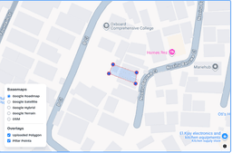
Polygon Generation
Turn ordered pillars into clean polygons; snap, close, and simplify geometry.
Nigeria Boundary Lookup
Instant ward/LCDA/LGA/state detection using spatial intersects.
Interactive Map Analysis
Pan, zoom, toggle layers, measure, and overlay pillars/polygons with boundary metadata.
Facilitator Console
Track certificates, statuses, and pending actions in one place.
From CSV to certificate
A minimal, auditable pipeline that just works.
- 1
Smart Form
Guided form for survey plan uploads, CSV import, map preview, and attribute entry.
- 2
Survey Plan Viewer
Interactive map viewer for visualizing, searching, and querying survey plans and parcel boundaries.
- 3
Dashboard
Central hub for managing plans, viewing recent activity, and accessing analytics.
- 4
SP-Code Verification
Protects survey plans with unique QR codes for public verification, ensuring authenticity.
Empowering Land Professionals
As land data becomes increasingly central to modern administration and planning, Surfboard provides the essential tools you need to stay ahead. Our comprehensive platform streamlines survey submission management, offers powerful plan visualization, and delivers strategic insights from spatial datasets—all in one intuitive interface.
"Transforming raw survey data into actionable intelligence."
Frequently asked
Can I upload survey plans outside Lagos?
Yes, you can upload survey plans for anywhere in the world.
Is every QR Code unique to a survey plan?
Yes, each survey record automatically generates a unique QR Code for secure identification.
When I scan the QR Code, will it show the location of the survey plan?
Yes, scanning the QR Code displays the location of the survey plan on an interactive map, along with additional details about the record.
Can I navigate to the location of the survey plan?
Yes, simply click 'View on Google Maps' to get directions to the exact location.
What is the required CSV file format?
Your file should have the following columns: Column 1: Pillar No, Column 2: X coordinate, Column 3: Y coordinate
Can I edit a record after upload?
Absolutely! You can click 'Edit' to make and save any necessary changes.
Can Surfboard auto-detect wards and LGAs?
Yes. Given polygon geometry, Surfboard intersects against a Nigeria wards dataset to return ward, LCDA/LGA, and state metadata.
Do you support big CSV files?
Yes. Large files are handled with streaming parsers and server-side validation; you'll see progress and row-level errors.
Is geometry required?
No. You can upload pillars only — Surfboard generates and validates polygons for you.
Ready to ship accurate survey plans?
Start with a CSV, end with clean geometry, boundary metadata, and audit-ready records.